TRAVELS WITH TOBY – WEEK SIX: Four down, four to go
Published 9:04 am Friday, April 15, 2022
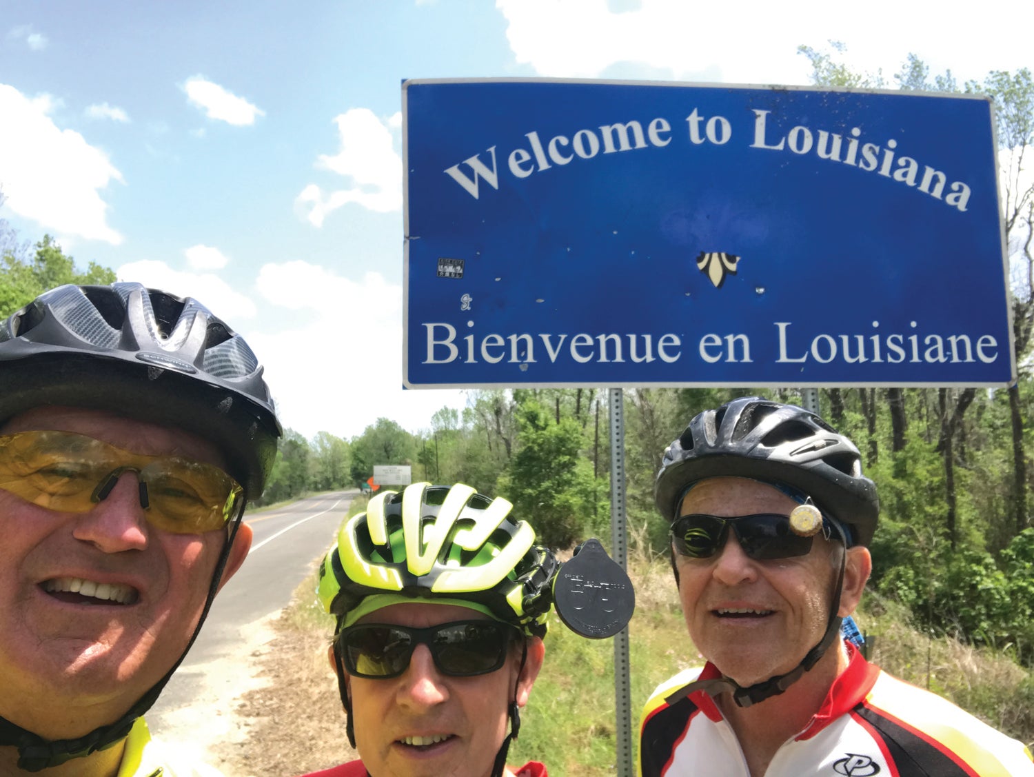
- (Above) Toby Thorpe, left, Earl McMahon and Mike Stanley arrive in Louisiana. (Contributed)
|
Getting your Trinity Audio player ready...
|
Thursday, April 7, Day 27
Bastrop to Branham, Texas
Cool temperatures returned to Central Texas as our rest day concluded and we pulled out of Bastrop, eastbound for Branham.
Toby Thorpe
With morning temperatures in the 40s and winds mostly behind us, we were able to move fairly quickly out of town and into the countryside, where horse and cattle ranches lined the main highways, the terrain became steadily less hilly, and the morning commuter traffic eventually waned. By mid-morning we had passed through the town of Paige and were nearing Giddens when Earl hit a piece of roadside debris and blew a tire within sight of where Keith had stopped the RV for our second rest break.
Upon examination, it appeared the tire itself was damaged beyond the roadside repair threshold, so he boarded the RV while Mike and I continued on.
The route from Bastrop to Branham took us along Texas Highway 21 and US Highway 290, both connecting the surrounding cities to the Houston area, so traffic was heavier than either Mike or I preferred to navigate, so, at our last rest stop of the day, about 17 miles outside of Branham, we consulted the ACA map and discovered a side road into the city.
Side roads shown on the maps can sometimes hold unpleasant surprises. At times they are poorly signed, in some cases the pavement ends after a few miles and on occasion they are little more than goat paths. But seldom do such alternate roads carry heavy traffic, so we rolled the dice and decided to take the alternate route into Branham, and we hit the jackpot. The road was smooth, low-traffic and passed through a number of very well-kept farms, ranches and countryside before depositing us on a side road just half a mile from our end point in Branham.
In Branham, Earl was able to visit a bike shop and procure a new tire for the next day’s ride into the easternmost reaches of Texas.
Friday, April 8, Day 28
Branham to New Waverly, Texas
Our trip out of Branham on Friday morning saw us navigate through the downtown of the city before heading through several small towns and a long stretch inside the Sam Houston National Forest. The only major city (if you consider a population of 7,700 “major”) we passed was Navasota, the final waypoint listed in Texas on the ACA cycling maps
We had been told that once we passed Navasota, we would enter “pine country,” and that statement proved to be true. Had I not known my location already, I could have believed I was in the North Carolina Sandhills region with the flat terrain and thick growths of pine.
In such isolated areas, unexpected occurrences can be more disconcerting than normal, and that was the case following our second rest stop of the day. Just after pulling out, Mike was in the lead, I was in the middle, and Earl was in the back when we crossed a bridge over a fairly deep creek gully. As I pedaled over I glanced to my right and saw a car sitting in the creek.
My first thought…a wreck…and we need to help! So I hollered up at Mike to stop, jumped off my bike and ran back on the bridge just as Earl pulled up wondering what in the heck I was doing.
It only took a second glance to see that I had overreacted. The car appeared to be a Ford Aerostar van, circa 1990, and had probably been fairly new when it went into the creek. The fact that the vehicle was completely devoid of windows and had various types of plants growing out of it eliminated the possibility of any injured humans remaining within. So, upon my issuance of an apology for slowing our travel, we moved on. Soon, we entered the Sam Houston National Forest, which, on a Friday afternoon, was busier than expected with ATV riders, motorcyclists, boaters and fishermen. The road through the forest led across Lake Conroe, a large man-made lake, before exiting the national forest on the outskirts of New Waverly. A photo stop on the bridge was our only pause before cycling into town.
Later that evening, we ate take-out from The Fish Pond, a restaurant between Willis and New Waverly with excellent food … the fried chicken dinner was definitely bigger than what you get outside Texas.
Saturday, April 9, Day 29
New Waverly to Kountze, Texas
For a cyclist, a new bike, a new route or some new gear are all treats that come along once in a while, and are niceties that keep us coming back.
But some things never change. One of the most aggravating for a cyclist is the attitude some folks hold that we have no business on the road.
Granted, there are some cyclists who will test the patience of those in motor vehicles, and those are the ones that give all of us a bad name. But in my 14 years of serious cycling, I have run across very few of these … and when I do, I try to make it a point not to ride with them any more.
On the flip side, nearly all of the cyclists I know do all they can to be safe. We know we are not going to win a battle with a car or truck, so we try not to increase the blood pressure of the people operating them.
Likewise, 95 percent of the motorists we encounter are courteous and considerate … if there is room for them to pass us, they give us more than enough space. If there is oncoming traffic, most will slow down until they can get around. And most who are coming the opposite way take care not to cross into our lane.
But there is that 5 percent …
We ran up on a 5-percenter on this Saturday between Cleveland, Texas and the Trinity River bridge. There was road construction in the area, and the pavement was milled in preparation for a new coat of asphalt. As a result of the rough surface, traffic was moving slowly in both directions. It was an otherwise pleasant morning when Mike, who was leading the pack, was targeted with a barrage of gutter language from a not-so-gentle man in a dump truck coming from the opposite direction. The language, which was far past PG, PG-13 and possibly even R standards, continued as the driver came by Earl and me. The subject matter involved our IQ, our heritage and whether or not our parents were married.
Hey, we are big boys. We’ve heard those words before, so that’s no skin off our nose. But what puzzled us was why this guy, who was completely unaffected by our presence on the road, wanted to spew such venom while we were minding our own business.
In any case, road rage is one of the things that cyclists seem to encounter on occasion. Fortunately, this is one of only a very few such incidents we have run into during this trip.
But the negative was far offset on this day by the positive. Cleveland was a neat little town, and we met two of its residents in a most unusual way.
Peddling in on a Texas farm road we were surprised to be greeted by the Easter Bunny, waving from the end of a driveway over a week earlier than expected. Upon reversing field to get a photo, the Easter Bunny’s agent (Jody Garland, manager of the Cleveland Best Western) informed us that that the Bunny (her daughter, Jamie) would indeed be willing to take a photo with us, and she wouldn’t even charge us the $10 name, image and likeness fee.
Hey, if it’s free, it’s for me.
So we posed for a shot with EB/Jamie, who, according to her mom/agent, is an aspiring model when not doing covers for Egg Hunt Weekly.
In all seriousness, watch for Jamie Garland in the future. She and her mother were very welcoming to us, and that’s something you don’t get from everyone.
Our final stop in Texas was the town of Kountze (pronounced “koonts”). It is about 15 miles from the Louisiana border, and would be our last overnight stop in the Lone Star State. It is home to Brookshire Brothers grocery, and a restaurant called Mama Jack’s (with a live band on Friday and Saturday), and we patronized both establishments before heading out of town the next morning.
Sunday, April 10, Day 30
Kountze, Texas to DeQuincy, Louisiana
Technology is a wonderful thing … when it works. So as we plotted out our next day’s route on Saturday night, maybe we should have considered the fact that the Ride with GPS app was showing two unnamed and unnumbered roads on our itinerary for the next day. But the app had not led us wrong before, so we trusted in its integrity for the next day.
Sometimes trust can be misplaced.
After navigating through the towns of Silsbee and Evadale we were drawing ever closer to the eastern border of Texas. Only one town, Deweyville, remained, and as we rolled to the intersection of highway 62, the GPS indicated that we should turn left and then take the first road to the right (unnamed and unnumbered), which would carry us through swampy lowlands to Deweyville.
The first road to the right appeared to be the same road Andy and Opie walk up while whistling at the beginning of each episode. Plus, it had a gate on it marked “Private Property.”
OK, no problem. Surely it didn’t mean that road.
Unfortunately, it did mean that road. The GPS went into convulsions when we rode by it, so we sent Mike back to scout things out. Maybe we missed something.
Nope.
Our next step was to pull out our backup, the ACA map, which showed that if we cycled up the road approximately three miles, a county road would take us over Deweyville. So off we went.
Sure enough, the county road was right there where the map said it should be, and we eagerly turned onto it and started eastward. But Earl, being the cautious one of the group, saw a gentleman pulling out from his house in a red pickup truck. He waved him down and asked if the road indeed went to Deweyville.
According to the red pickup truck man, the road “used to go all the way through, but a hunting club bought property on the road and gated it. You might can get through if the gate is open,” he said.
It’s Sunday morning at 10 a.m. Fat chance there is a hunt going on right now. And we didn’t want to ride all the way to the hunt club to find out.
So, it’s Keith to the rescue. He had been waiting on us in Deweyville, having followed normal driving routes not recommended for cyclists. We reached him by phone and arranged for him to meet us a little ways up the main road. He found us, then informed us that his GPS brought him across a dirt road to our location, which gives new meaning to the saying, “You can’t get there from here.”
Within a few minutes, Keith had picked us up and shuttled us over to Deweyville where we hopped back on the route and within minutes had crossed the Sabine River into Louisiana, where our end point would be the town of DeQuincy and the Willow Ranch RV Park.
Louisiana, although we had entered the far western reaches of the state, had an entirely different look and feel than Texas. For one, the roads were a bit straighter, but also rougher. Instead of cattle and horse farms, we mostly saw acres and acres of cypress swamps. And it seemed that timber was the big industry, as there were numerous sawmills and lumber yards along the way to DeQuincy.
And, despite the directional challenges, we were happy to have another state checked off our list. It’s four down and four to go. We are on the home stretch.
Monday, April 11, Day 31
DeQuincy to Opelousas, Louisiana
With this day marking one full month since having dipped our rear tires in blue Pacific and headed east, we should have expected a significant occurrence to mark the milestone. And we got one — a thunderstorm.
Thunderstorms in the spring are a common occurrence back home. But since leaving San Diego on March 11, we had seen no significant rain. We did experience a 30-second sprinkle while staying at Safford, Arizona, but nothing else. Not a drop.
Just as Earl, Mike and I were getting on the bikes and preparing to pull out, a big rumble rang out. However, there were railroad tracks through the woods, and we thought that might be the culprit. The sun was breaking through the clouds, and the forecast called for “scattered afternoon and evening thundershowers,” so we continued with our preparations.
The next clap of thunder left no doubt as to its origin, as it included a nice flash of electric light that sent us scurrying into the RV.
Within a few minutes we were in the midst of a downpour that would otherwise have seemed hum-drum. But after seeing no rain, very few clouds, and bone-dry conditions for a month, it was difficult not to go out and splash in the puddles like a kid.
The down side of the rain was that it was going to delay our start. We could have ridden in the rain — all of us have had to do it at some time or another — but quite frankly, we didn’t have to, so we weren’t going to. We used the morning hours to catch up on route planning and other important matters (snacking).
By noon, we were on the road, well fed and moving slowly eastward toward our end point for the day. The thunderstorms had passed, but a strong headwind remained. So, as we pedaled past rice fields, oil wells and farm equipment dealerships, interspersed by the towns of Eunice and Opelousas, we alternated between fighting the wind blowing over open fields and enjoying occasional breaks as we traversed forested areas and the buildings of the towns.
By late afternoon, and after fighting heavy traffic through Opelousas, we found our campsite for the night to be a pleasant break from a long day, as it was nestled among moss-filled oaks in a cool and shady grove about five miles past Opelousas.
It made for a nice ending to a longer-than-normal day.
Tuesday, April 12, Day 32
Opelousas to Baton Rouge, Louisiana
As we headed out of our campsite for a shorter-than-normal mileage day (60 instead of the usual 70), we knew we would have a major bridge to negotiate — the Huey P. Long Bridge across the Mississippi River on US 190 entering Baton Rouge. Supposedly it was accessible to cyclists, but nearing a city of 200,000-plus, we knew that traffic would likely be an issue. What we didn’t know was what we would encounter just 17 miles into the ride.
As usual, we had sent Keith up the road to wait on us for our first rest stop, and his first opportunity to stop and wait on us was just short of 17 miles, just prior to crossing the Atchafalaya River. The bridge superstructure stood high above the flat landscape as we stopped to grab some water in a convenience store parking lot while ever-curious Earl quizzed a local on the bridge’s bicycle-friendliness.
The report Earl brought was unexpected … apparently, cycling across the bridge was no problem, as the road had an adequate shoulder. But what lay beyond the bridge was not mentioned in either ACA or Louisiana DOT literature … a five-mile narrow and elevated roadway across swamp land with no shoulder, concrete railings on both sides, and no exits.
“He said he sure wouldn’t try it on a bicycle,” said Earl, referring to the local man he spoke with.
The result? We loaded the bikes on the RV and had Keith shuttle us to the end of the elevated roadway.
Some might call that cheating. We call it survival.
Back on the bikes for about 30 miles, we looked ahead for the next bridge which would take us across the Big Muddy and into Baton Rouge. At the western end of the bridge, we again found Keith.
“I’ve scouted it out,” he said, “and I don’t think you want to pedal across this one either.”
Apparently, when the Huey P. Long Bridge was built, no serious consideration was given to pedestrians or cyclists. Like the elevated roadway at the Atchafalaya, the lanes were narrow with no room for cars to pass a cyclist or a walker. So again we shuttled the bikes the half-mile across the river.
With the two shuttle trips, a major objective of the day was met … none of us would become a hood ornament today.
Next, we had to pedal through various sections of Baton Rouge to reach our overnight site near Louisiana State University. After pedaling along what seemed to be a never-ending Exxon-Mobil refinery along the river, we were able to cut through a couple of residential sections to reach our overnight spot, an Econolodge just off the LSU campus.
And we arrived none too soon, as a severe thunderstorm hit within a half-hour after we arrived. I’m guessing those two shuttle trips on the RV kept us from getting caught in that too. Sometimes being careful carries additional benefits!
Wednesday, April 13, Day 34
Baton Rouge to Mandeville, Louisiana
Our final pedal day before our Thursday rest day would take us from Baton Rouge to Fontainebleau State Park in Mandeville, on the shores of Lake Pontchartrain, about 20 miles north of New Orleans. We knew it would be a long pedal day. What we didn’t know is that we were going to make it even longer.
Pedaling out of Baton Rouge on US 190, the morning traffic was heavy, and the lack of a paved road shoulder made the first 10 miles nerve-wracking before the road widened out near the community of Holden, our first rest stop.
At Holden, we picked up state road 441 and headed south across Interstate 12, then turned east on state road 22, which we would follow through Springfield and Ponchatoula all the way to Mandeville. Sounds easy, right?
Earlier, our GPS had messed us up in Texas by directing us across some non-existent roads. But what we were about to do cannot be blamed on the GPS. No, this was 100 percent pilot error times three.
As we passed through the small town of Springfield, route 22 turned to the left toward Ponchatoula. But somehow all three of us missed the sign and continued straight ahead onto state road 42, where we pedaled for about seven miles, the last three looking for Keith, who was supposed to be in the parking lot of a Dollar General in Ponchatoula.
When we had determined that our location was too desolate for even Dollar General to locate a store there, we decided to consult the map. That’s when we came to realize we were not only off course, but were headed back to the west. A quick call to Keith, who agreed to meet us in Springfield, limited our mileage overrun to only 14 miles.
Back on course, we cycled into Ponchatoula, a town I had last been to seventeen years ago when my younger son played in a Dixie Baseball tournament there. Only a couple weeks after the tournament, Hurricane Katrina wreaked havoc on Louisiana, and we heard that the areas around Ponchatoula, Hammond, and Covington had all been heavily damaged.
While off course outside Springfield, we could see that many of the structures there had been abandoned after Katrina, and numerous damaged houses and storefronts were literally rotting away. It was sad to see, and I expected to encounter the same in Ponchatoula. But as we pedaled through the town, it seemed more vibrant and attractive in appearance than it had back in August, 2005. The streets were busy, downtown was bustling, and businesses there seemed to be thriving. It was nice to see, for I had expected more of what I had seen around Springfield.
Another pleasant surprise awaited us in Mandeville … a break from traffic. The town has developed an abandoned rail line into a greenway called the Tammany Trace Bike Trail. We were able to pedal the last five miles into Fontainebleau State Park free from vehicle traffic, and proceed directly to our campsite, where we will take a day’s rest on Thursday before heading for Gulfport, Mississippi on Friday morning.
In addition to the usual rest day chores, I plan to interview Pastor Robert Williams, a North American Mission Board church planter in New Orleans, to explore how the Annie Armstrong Easter Offering provides support and assistance to churches and home missionaries in Louisiana and the south-central United States.
Hopefully, the interview will be available for viewing on the Pedaling4Annie Facebook Page by the weekend.
Thanks to all who are following our trip via the Facebook page and also via the Stanly News & Press. I encourage everyone to remember what the Easter season represents, and why we observe it.
Best wishes to all for a wonderful and meaningful holiday!
Toby Thorpe is a retired parks and recreation director and a freelance writer for The Stanly News & Press. He will file reports from the road for The SNAP. To donate to his fundraising effort (the Annie Armstrong Easter Offering – North American Missions Board), visit https://www.namb.net/give or www.northalbemarle.com/ways-to-give. Follow along as well using #pedaling4annie.