TRAVELS WITH TOBY WEEK THREE: Two states down, six to go on our journey
Published 11:17 am Thursday, March 24, 2022
- Interesting signs have dotted the roadways along the cyclists’ journey.
|
Getting your Trinity Audio player ready...
|
Thursday, March 17, Day 7
Rest Day in Wickenburg, Arizona
After six days of pedaling over two states, our first scheduled rest day was a welcome thing, however, “rest” is a relative term on a trip like this.
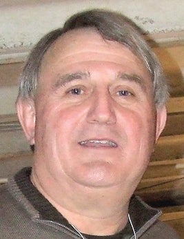
Toby Thorpe
While we did take a break from pedaling, there were a number of chores to do, which actually started upon our check-in on Wednesday. Washing, lubing and performing basic adjustments and preventive maintenance on the bikes was at the top of the list. Washing out six days’ worth of smelly bicycle jerseys, shorts and socks was a close second.
Those priorities would have been reversed had my wife been along.
The next morning, I was privileged to meet with Alex Dennis, lead pastor and church planter for Asante Church in Surprise, Arizona, just northwest of Phoenix. Associate Pastor Jacob Stephenson and church member Adam Ciarialo also made the trip up to our campsite to record an interview about how the Annie Armstrong Easter Offering benefits missions in the Phoenix area. We had a great time recording the interview and a great lunch afterwards. The video interview, in addition to one that Alex did with me to explain how the trip came about, can be seen at the Pedaling for Annie page on Facebook.
Friday, March 18, Day 8
Wickenburg, Arizona to Apache Junction, Arizona
Friday morning found Mike, Earl and me heading down Arizona Route 74 toward Phoenix. We had carefully plotted our route along a number of designated bicycle routes through the enormous sprawl not only of Phoenix, but a number of surrounding cities as well.
Keith, our driver, rather than attempt to follow us through the city, went ahead of us, and we agreed to rendezvous with him in the parking lot of the Arizona State University football stadium, in Tempe, which is southeast of Phoenix. He had driven on and was well on his way when I realized I had pulled the biggest bonehead move of the trip so far.
I had left the map in the RV.
After looking for a hole to hide in and finding none, I was relieved to discover that my two fellow riders did not intend to shoot me. Instead, we talked and agreed to try to navigate in the general direction of Tempe.
That worked for about five miles, after which we determined that the street we were following had taken a long, gentle turn and we were heading due west. So after stopping at a convenience store to seek direction, we were blessed to encounter a fellow cyclist who knew the area well. He gave us directions to follow two bicycle-pedestrian paths along the city’s canal system. His directions, along with a couple of emergency Google Maps consultations, took us directly to Sun Devil Stadium in Tempe, where Keith was waiting in the RV with plenty of water.
I didn’t touch the water, however, until I had the map in my pocket.
Leaving Tempe, we headed through the cities of Mesa and Apache Junction, which were stark contrasts for cyclists.
Mesa, a city of approximately 400,000, has bicycle lanes on every street. In addition, the public seems to have been educated on “sharing the road,” and the courtesy of the drivers was impressive.
On the other hand, Apache Junction, a neighboring city and our end point for the day, had no bicycle amenities, no bicycle lanes and motorists who shared the road somewhat grudgingly.
By day’s end, we had covered 83 miles, our longest single-day total for the trip to that point, and were ready for mass quantities of food and water.
Saturday, March 19, Day 9
Apache Junction, Arizona to Globe, Arizona
We anticipated that traffic might be heavy on Saturday morning, so we made a group decision to rise early, depart early and hopefully arrive at our destination early.
The first two actions fell into place as we hit the road shortly after dawn. But our third objective bit the dust soon thereafter.
Benjamin Franklin said that two things in life are certain: death and taxes. Obviously, Ben was not a cyclist, or he would have added a third item … flat tires.
We were barely five miles out of Apache Junction when my front tire blew after I hit a piece of debris along the shoulder of the road. Fortunately, there was no tire damage, and it occurred at a place alongside the road where we had lots of room to change the tube and start rolling toward our first stop, the town of Superior.
Superior sits at the foot of Queens Creek Canyon on US 60. We knew we would be in for a long climb as our map indicated a winding road that traversed a wonderland of rock formations, scenic views and small towns.
A bridge across the canyon just east of Superior was nerve-wracking to pedal across, but offered a great birds-eye view of the terrain below. Soon after the bridge was a tunnel, at which we arranged to meet Keith and have him follow us through. True to his basketball coaching background, he used the RV to set a perfect pick for us as we pedaled through the tunnel with no worries about being run down by trailing traffic. Upon emerging from the tunnel, we all stopped and took a few pics before pedaling on.
The top of the day’s climb would be at a town named “Top of the World.” And although the name created anticipation for our pedalers, the result was disappointment. Unfortunately, Top of the World had seen its economy bottom out some time back. All that remained were numerous abandoned buildings … a shame for a community located in such a promising area.
Rolling downhill through the towns of Miami and Claypool, and into Globe, our end point for the day, we learned that much of the economy of these central Arizona municipalities is tied into copper mining. This is evident from the visible mining operations on the mountain sides as well as signage and businesses in the towns.
What had been only a 57-mile segment felt like twice that distance, but the incredible sights along Queens Creek Canyon had made it worth the effort. Later that evening, falling asleep was no problem.

Mike Stanley, left, Earl McMahon and Toby Thorpe may a quick stop at the Continental Divide. (Photo by TOBY THORPE)
Sunday, March 20, Day 10
Globe, Arizona to Safford, Arizona
Sunday morning dawned sunny and windy over the RV park in Globe, but the wind was blowing due east … a good thing for cyclists traveling in the same direction.
With 78 miles ahead of us, and a downhill that would level out as we approached our next stop in the town of Safford, the tailwind was a welcome boost as we pedaled away from Globe and into the San Carlos Indian Reservation along US Highway 60. To our left were impressive rock formations along the mountaintops on the reservation, with flat, sandy land with occasional cactus and low bushes on our right.
As we left the reservation a little more than halfway to Safford, it became evident that what had started as a tailwind had shifted, and was now coming from the southwest. In addition, the wind had become stronger and more gusty, yet was still enough to our back to serve as a boost.
After leaving the reservation, our route took us away from the mountain peaks and through flat crop land, with no wind breaks whatsoever. By the time we reached the outskirts of Safford, the wind had turned directly perpendicular to our route with gusts so strong that it became difficult to remain upright on the bikes. Fortunately, our campground was only about a mile off the road, but located to our south, which forced us to pedal directly into the wind for 1.1 miles … the most difficult 1.1 miles of the day!
Monday, March 21, Day 11
Hunkered down in Safford, Arizona
Upon rising early Monday morning in Safford, it felt as if the RV was a rowboat on rough seas, as the winds, which had only strengthened overnight, rocked the vehicle constantly. A quick check of the forecast revealed that the entire southeastern portion of Arizona was under a high wind warning, with sustained winds of 25-35 and gusts exceeding 50 … almost twice what we had dealt with the previous day. We decided by a vote of 5-0 (I voted twice) to sit tight for a day rather than risk getting blown in front of a truck on US 60.
The off day allowed us to visit the local bike shop, run by a gentleman named Tom who had ridden in from Pennsylvania many years earlier and never left. He was glad to sell us inner tubes to replace the ones we had already blown.
We also learned about a local phenomenon, a rock known as saffordite. It apparently is only found in about a 100-mile radius of Safford, and is of meteoric origin. The stone appears to be just a black rock, but light from a flashlight can be seen through it. Many locals believe the stone has wish-fulfilling powers, but I was impressed enough with its translucence.
The weather forecast for Tuesday appeared much better wind-wise, but somewhat worse temperature-wise. Since we figured we can put on enough clothes to stay warm, we planned to pull out for Lordsburg, New Mexico on Tuesday morning.
Tuesday, March 22, Day 12
Safford, Arizona
to Lordsburg, New Mexico
As advertised on Accu-Weather, Tuesday dawned cool (40 degrees) and breezy, and Earl, Mike and I dug out our cold-weather apparel and layered up before hitting the road.
One of the most impressive sights in Safford is Mount Graham, a 10,400-foot high mountain overlooking the town from the southwest. Its peaks had been snow-covered throughout our visit, and this morning seemed to be even whiter than before, likely the result of freezing fog around its summit.
We got a pic with the big mountain in the background just before hitting the road.
On our way out of town, we encountered a number of other cyclists making the same trip as us, but doing so in tour groups. We had checked into this possibility, but the cost was prohibitive (they stay in hotels almost every night, and eat high on the hog).
Yep, we are tightwads and proud of it.
A few miles past Duncan, a small town which claims Sandra Day O’Connor as an alumnus of its high school, we left Arizona behind and entered our third state, New Mexico.
According to Adventure Cycling, we will only pass through the “boot heel” of New Mexico before passing into Texas in about four days. But our first stop in New Mexico, Lordsburg, which is located in what locals call “high plains,” was a welcome sight after 78 miles, albeit a cold one.
Wednesday, March 23, Day 13
Lordsburg, New Mexico to Deming, New Mexico
When we pulled out of Lordsburg on Wednesday morning, the cold weather gear was in order once again. At 8:30 a.m., the temperature as we pedaled out was only 38, and we headed into a steady 20 mph headwind.
In most cases, Adventure Cycles routes Southern Tier cyclists along less-traveled back roads, but in some situations the only option is to pedal along the shoulder of an interstate highway. That was the case today. For the first 40 miles of a 60-mile pedal, we ran along the shoulder of Interstate 10, buffeted by tail winds of 18-wheelers. Fortunately, about 20 miles out of Deming, our next stop, we were able to exit onto a frontage road which we were able to follow into town.
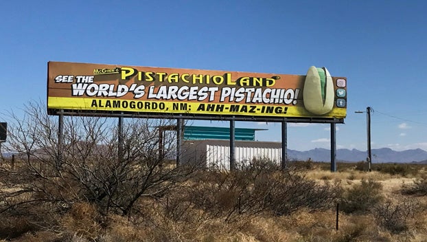
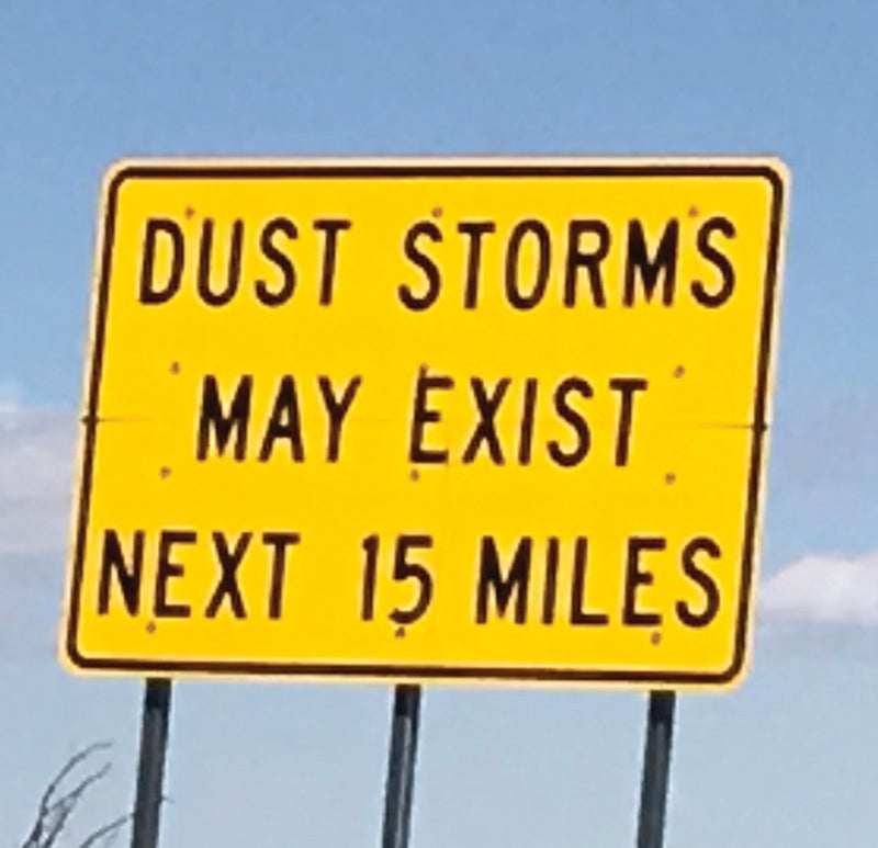
One interesting sight along the interstates are the signs and billboards. They range from the ominous (“Dust Storms Possible Next 15 Miles”), to the ridiculous (“See the World’s Largest Pistachio at Alamogordo”), to the repetitive (“Visit Bowlin’s Continental Divide Trading Post”) with a billboard every 500 yards for what seemed to be 20 miles.
So tonight we will stay in Deming, New Mexico before departing Thursday for Las Cruces. By next week, we should be well into Texas, where we will be for a while.
CLICK HERE FOR LAST WEEK’S INSTALLMENT.
Toby Thorpe is a retired parks and recreation director and a freelance writer for The Stanly News & Press. He will file reports from the road for The SNAP. To donate to his fundraising effort (the Annie Armstrong Easter Offering – North American Missions Board), visit https://www.namb.net/give or www.northalbemarle.com/ways-to-give. Follow along as well using #pedaling4annie.